241 Things

1000 Things is a subjective encyclopedia of inspirational ideas, things, people, and events.

Read the most recent articles, or mail the to contribute.

Studium Generale 1000things lectures, The Hague

241 Things


People often think that science strives for truth, but this isn’t always the case. We’re usually searching for the answers to concrete questions, and these answers often find their form through models.

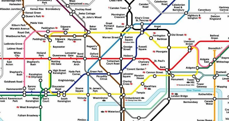
A good example of this is the tube map. The tube map is a complex system consisting of grids and lines. It is, first and foremost, a depiction of the system as it is.

In the 1930s, the underground became increasingly complex. People don’t handle complexity well, they prefer things simple. Harry Beck redesigned the tube map so that it was no longer based on geographical distance but on where to change trains. Instead of representing reality, the map caters to the needs of its user.

Models are developed, and questions are answered by creating models. The function of a model is that it attempts to understand in order to answer a question or purpose.

Map, 2006-2010

Map, 2006–2010

Map, public installation, 2006-2010

dimensions: 600x350x35 cm
material: wood board, wood beams, color, wire, screws, glue, nails,

Map, 2006-2010

Map, 2006-2010

Map, 2006-2010

Map, 2006-2010

Related to the idea of Dataspace is the project 'Map' by German artist Aram Bartholl. It is a public space installation that questions the red map marker of location-based search engine Google Maps. "Find local businesses, view maps and get driving directions in Google Maps." With a small graphic icon Google marks search results in the map interface. The design of the virtual map pin seems to be derived from a physical map needle. On one hand, the marker and information speech bubble next to it cast a shadow on the digital map as if they were physical objects. When the map is switched to satellite mode it seems that they become part of the city. On the other hand it is a simple 20 px graphic icon which stays always at the same size on the computer screen. The size of the life size red marker in physical space corresponds to the size of a marker in the web interface in maximal zoom factor of the map. Where is the center of a city?

Map, 2006-2010

Part of a series, 'Map' is set up at the exact spot where Google Maps assumes to be the center of the city. Transferred to physical space, the map marker questions the relation in which the digital information space stands to public city space, the space of everyday life. The perception of the city is increasingly influenced by geolocation services.