239 Things

1000 Things is a subjective encyclopedia of inspirational ideas, things, people, and events.

Read the most recent articles, or mail the to contribute.

Studium Generale 1000things lectures, The Hague

239 Things

Walking past a traffic light in Larkhall reveals a hatred for green. While in other cities the red light would turn to green, in Larkhall it changes to clear when the cars rush off. There is no option for green since the lights have been smashed. Again.

The first time I was confronted with this – most likely – urban myth I was shocked. But a little research reveals that everything in the city is about blue and the hatred of green. Hatred is revealed itself in many common phenomena, and in Larkhall it’s green that provokes so much revolt. The city of Larkhall is situated close to Glasgow. It is the only city where the sandwich chain Subway doesn’t have a green front but a black one, where the pharmacy doesn’t have the usual green sign and the fences are blue. Not to forget that they “pish” on the grass due to it’s green colour.

So from where does this hate actually originate? The main reason lies in football. When the blue protestant football club ‘The Glasgow Rangers’ play against the green catholic club ‘Celtic’ – ‘The Old Firm’ - riots always ensue. It’s the moment where hooligans fight against the green in Larkhall and traffic lights get smashed.

The Glasglow Rangers in revolt!

I managed to get in touch with a ‘wee’ Scottish woman that used to work as an english teacher in Larkhall. When asked, she told me that everything in this town revolves around sectarianism. When students find out your Celtic preference they often are outraged and sometimes even throw chairs at you. However, that’s not the worse thing that can happen. A fellow colleague was evenstabbed because of this sectarianism. No wonder there is a uniform fear within the town, with companies also following the colour preferences and attempt to eradicate green, possibly in fear of being stabbed.


I often cycle from Amsterdam to the polder and cut through the Bijlmer. Yes, for the simple reason of finding pleasure and enjoyment in the cycle ride.

In the area that connects these two regions, I spot a large empty parking lot in the distance. There, in a small strip at the side, three aluminium boxes are piled on top of each other onto a construction with legs. Sort of like a three tiered barbeque. Beside it, a car is parked next to which a man and a woman are preparing a cup of tea. I ask them what they’re doing. Pigeons. They’ve transported these homing pigeons from Zaandam to here, where they’re training the pigeons to fly both long and short distances. Since they’ve only just arrived, the pigeons need to acclimatise for a little while, otherwise their orientation skills may falter.

There are some 57 pigeons in the aluminium construction. Later on, they’ll be released and will have to find their way home. Their sense of direction is guided by the magnetic field.

“Disruptions in the magnetic field have meant that the pigeons are becoming more prone to getting lost than before’, the homing pigeon hobbyist explains. ‘The magnetic field is disrupted by mobile phones, by everything that is sent via airwaves’. ‘Is there no more room in the air?’

‘For example, if you pay attention, you’ll see many pigeons in the Dam with a ring around their leg. These are carrier pigeons that have lost their way. In fact, the other day a man from Krommenie called me to see if I could pick up my pigeon from him. Pigeons fly in groups, first in a circle around the area where they’ve been released, then they’ll pick up speed and fly away. But nowadays they seem to get lost quite often.’

‘It’s a wonderful hobby’, the man excitedly tells me. ‘`It’s so relaxing.’ He bares his perfectly white teeth in a broad smile. When he speaks, saliva sputters in all directions, but, oh well, that’s probably just because of his dentures

Then they release the pigeons and I watch as they circle around and fly away, and they’re as beautiful as a flock of sparrows.

I love to watch road works at night, to bear witness to such theatrical, ceremonious acts (involving hot tar, smoke, neon outfits and line marking), located within nocturnal life. These are the people carving out our city, while we sleep.

Who owns the roads of the city? The veins so to speak, leading us from A to B. It is not these people marking out and sculpting our floor space. Moreover, is it possible to own a route of a city? I certainly do inside of my head, through personal shortcuts and secret off-piste meanders.

Lately I have experienced the proliferation of branding colours, which corporate businesses use as a tool in order to corner us into acknowledging their existence – smartly working from the ground UP. Take the Barclays’s blue etched into the lanes of our roads – the fast-moving concrete river facilitating endless bikes and Borris bikes around our city. This blue then morphs from micro dashes of the colour to vast infinite pools of it. Such colours are present in pixels, credit cards, billboards, signage, tennis courts etc...Cobalt blue will never be the same again!

I also find it interesting in terms of facilitating movement of people around a city and the parallels that can be drawn with liquidity of money or cash flow of an invisible market.

When cycling around London, I have been collecting images of cosmic rings, which appear in particular weather conditions. They are short-lived abstract forms created by oil present on the ground. These psychedelic rings have triggered an investigation towards the privatisation of floor space. These rings function as hazard signage on the road; warning of space and the privatization of floor space.

I have been drifting along on my bike thinking about the ground below us. When does the earth's crust begin? Coating the top, below our feet I have recently noticed that floor space is being privatized in a different way. And has started to connect our mind to our physical bodies pushing them through the space of a city. We are beginning to live in a society whereby everything encompassing our bodies has some kind of corporate context. Sometimes I feel as though we are inside of a theatre set made up of various components not chosen by us: trade, pollution, industrialisation, movement, bodies, space, time, market, economy, upkeep.

Abandoned cities, Yangtze river
Abandoned city Russian city
abandoned settlements of Antarctica
Ghosts towns Eurasia

The Principality of Sealand

Abandoned cities, Yangtze river
There are few abandoned places in our crowded, fully designed and predetermined country. The Dutch, after all, are very fond of tidying up. Usually, a property will be torn down or repurposed before it even has the chance to fall into disrepair. But many large parts of The Netherlands are dealing with shrinking populations. As a result, the quality of life in many villages is under pressure because amenities such as schools, community centres, and supermarkets are disappearing.
Abandoned cities, Yangtze river

However, the emptying of villages hasn’t yet had the ultimate of extreme results: the total vacancy of villages and neighbourhoods. And although places like Delfzijl and Heerlen are dealing with a decline in population, it’s probably not an irreversible process as of yet.

Abandoned cities, Plymouth

For many places outside of The Netherlands it’s too late, they’ve been abandoned.

Like many other architects, we love to stroll around both new and familiar cities and villages, on the lookout for inspirational spots. Often, these places are deserted by people.A place that was once inhabited, but now left behind, is fascinating. You find yourself somewhere no one lives anymore, but where the presence of habitation is still to be sensed, and where the promise of what may come triggers the imagination. You’ll find yourself in the present, the past, and the future all at once.

Abandoned cities

Our interest in collecting abandoned places was sparked by seeing Spelling Dystopia, a video work by Nina Fischer and Maroan El Sani. Spelling Dystopia econmpassed that feeling of being in three time zones at once. Images of an island completely deserted, but at the same time full of buildings, are interjected with images from videogames: Hashima. This fascinating island that, surprisingly, actually exists has recently become well known as the Bond villain Roaul da Silva’s headquarters in the film Skyfall.

abandoned settlements of Antarctica

The abandoned places we collect are often photogenic, but their background stories are usually anything but pretty. At times the stories backing these desolate places are more intriguing than the visual image of their forsaken nature. For some places, human failure is why inhabitants have been forced to bid their homes farewell, for others it’s the uncontrollable hand of nature. Many times, greed and apathy are the cause. Man came, saw, used, and discarded.

Ghosts towns Eurasia
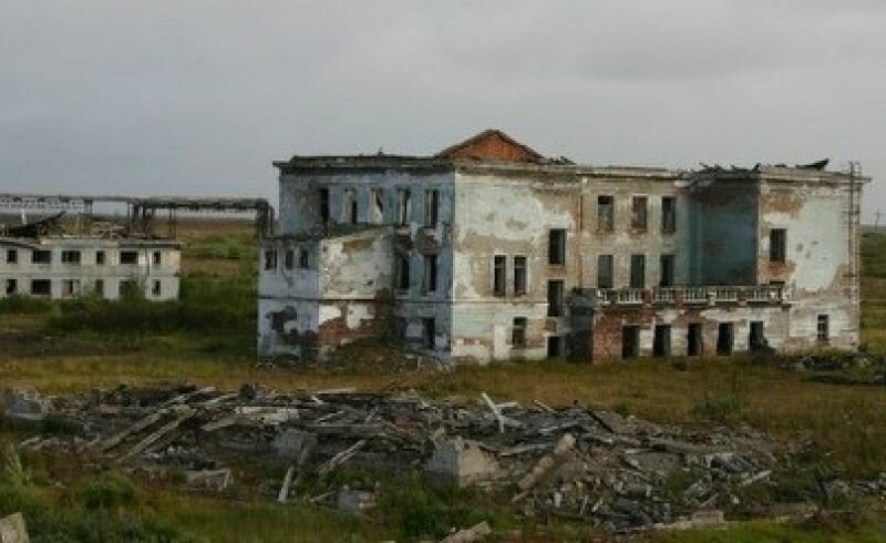
Among the abandoned cities and territories we’ve mapped are many regions where mineral resources were extracted. But after resources are spent, work opportunities decline, and inhabitants move away. Like in the Kolmanskop in the immense Namib Desert where there was an immense diamond rush in the previous century. According to the tales, those in search of fortune would scan the desert sands by moonlight. In this place the Germans built Kolmanskop, equipped with every possible comfort: luxury in the middle of the desert. But as fewer diamonds were found, fortune seekers went elsewhere to find their luck and Kolmansdorp was left behind. Those who visit the village now will find the old villas, covered in metres of sand.

While a forsaken, once inhabited place is interesting, an abandoned but never inhabited place might be even more fascinating. In China, hundreds of new cities are built to house migrants that make their way from the country to the city. The problem with this lies in the fact that these houses are usually too expensive for the migrants. The middle class buys these properties as investment pieces, without actually living in them. Everything is brand new here: new roads, buildings, a city park including a bright and shiny new museum. Traffic lights that jump colours while there’s no one to partake in traffic.

Abandoned cities, Plymouth

One of the abandoned places included in our publication is the Maunsell Forts. These forts are abandoned due to the lack of a threat of war. Not a village, not a city but a collection of platforms that housed enough troops to be considered a village. All but one of these platforms have been abandoned and delivered to the elements. To destroy them would be costly, and moreover, the platforms are part of history. It’s that one inhabited platform that, once again, fuels the imagination. Former radio pirate, the late Paddy Roy Bates and his wife, took residence on one of the platforms, declaring it the Principality of Sealand. His son, Prince Michael, now rules over the smallest, unrecognised European state presiding over no more than five souls but that nevertheless issues its own passports, stamps, coins, and even has its own football team. Adaptive reuse at its finest.

The Principality of Sealand

Abandoned Cities is the result of our archiving until now. We’ll continue by mapping the places we’ve encountered on the globe and by adding information to the places we’ve already marked. The next step is the actual research. Categorising the locations, finding similarities and differences, discerning possibilities and threats. Formulating the parameters for villages and cities full of vitality. Locating places where the tide could still turn through urban design or architectonic interventions. But also to see shrinkage and the accompanying vacancy as a serious but likewise valuable element to the constructed environment.

Chernobyl plant
San Zhi Abandoned cities

Willemien van Duijn en Lieuwe Vos, Abandoned Cities, BNA 2012 (Freestyle 3)

Map, 2006-2010

Map, 2006–2010

Map, public installation, 2006-2010

dimensions: 600x350x35 cm
material: wood board, wood beams, color, wire, screws, glue, nails,

Map, 2006-2010

Map, 2006-2010

Map, 2006-2010

Map, 2006-2010

Related to the idea of Dataspace is the project 'Map' by German artist Aram Bartholl. It is a public space installation that questions the red map marker of location-based search engine Google Maps. "Find local businesses, view maps and get driving directions in Google Maps." With a small graphic icon Google marks search results in the map interface. The design of the virtual map pin seems to be derived from a physical map needle. On one hand, the marker and information speech bubble next to it cast a shadow on the digital map as if they were physical objects. When the map is switched to satellite mode it seems that they become part of the city. On the other hand it is a simple 20 px graphic icon which stays always at the same size on the computer screen. The size of the life size red marker in physical space corresponds to the size of a marker in the web interface in maximal zoom factor of the map. Where is the center of a city?

Map, 2006-2010

Part of a series, 'Map' is set up at the exact spot where Google Maps assumes to be the center of the city. Transferred to physical space, the map marker questions the relation in which the digital information space stands to public city space, the space of everyday life. The perception of the city is increasingly influenced by geolocation services.